HABs produce toxins that are dangerous to humans and animals. In 2024, data show decreased cyanobacterial levels and HABs incidences in waterbodies throughout the Delta.
The Measure
Spatial coverage of freshwater harmful algal blooms (HABs) in select waterbodies in the Delta is reduced.
-
Expectations
Spatial coverage of freshwater harmful algal blooms (HABs) in select waterbodies in the Delta is reduced.
-
Performance Metrics
- Spatial coverage (acres) of Microcystis sp. cell concentration equivalents (cells/ml), in Delta waterbodies large enough to use the State Water Resources Control Board mapping tool
Cyanobacteria Harmful Algal Bloom Monitoring Strategy for the Sacramento-San Joaquin Delta
A Cyanobacteria Harmful Algal Blooms Monitoring Strategy for the Sacramento-San Joaquin Delta (strategy) was released in 2024 with objectives to:
- Establish a monitoring program for Cyanobacterial HABs in the Delta,
- coordinate the collection of priority data,
- promote data-sharing, and
- identify feasible mitigation techniques for reducing HAB prevalence.
The strategy includes several goals, objectives, and recommendations as well as near-term and long-term implementation.
The ongoing activities that stem from this strategy will continually be tracked and highlighted for this performance measure. An established monitoring program for the Delta will be key to performance measures tracking and evaluating the status of HABs in the Delta.
Harmful Algal Blooms Satellite Tool
In 2019, State Water Resources Control Board and the San Francisco Estuary Institute released a satellite imagery tool which estimates the amount of cyanobacteria in large water bodies calculated in satellite imagery. It includes approximately 250 water bodies in California. It is designed as a screening level analysis tool, which can prompt field verification and sampling for local and state agencies to confirm if cyanotoxins are present. In addition, the satellite tool contains several disclaimers and limitations. Please refer to their website (linked above) to view any additional information about the data.
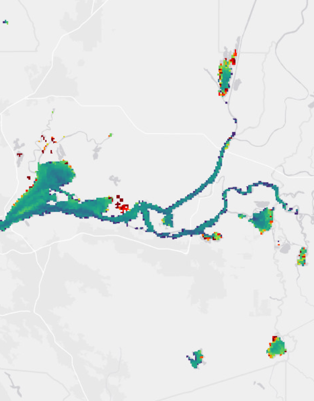
HAB Satellite Analysis Tool
Incident Reporting of Harmful Algal Blooms in the Delta
The map below displays the location of HABs incidences in the Delta during 2024. Data are from the HABs Incident Reports Map, which is a tool that shares locations and details of HABs that have been reported by the public, local or state agencies, and/or routine monitoring events.
For more recent updates and additional information, visit the link labelled HABs Incident Reports Map.
Trigger levels for posting planktonic advisory signs and description of advisory levels:
| Advisory Level | Description |
|---|---|
| Caution | Harmful algae may be present in this water. |
| Warning | Toxins from algae in this water can harm people and kill animals. |
| Danger | Toxins from algae in this water can harm people and kill animals. |
Additional information on advisory and trigger levels can be found on the California Cyanobacteria and Harmful Algal Bloom Network’s (CCHAB) website.
Next data update: Visualizations will be updated shortly after the end of the calendar year.
Algae are natural components of marine and freshwater ecosystems and form the foundation of most aquatic food chains. However, when blue-green algae, also known as Cyanobacteria, is present during an algae bloom event, it has the potential to be harmful to humans and wildlife (hence Harmful Algal bloom, HABs). Blue-green algae is often confused with green algae because both may produce dense mats, reduce oxygen levels, affect odor, and/or impede recreation; however green algae generally do not produce toxins. Blue green algae or cyanobacteria on the other hand, has the potential to produce harmful toxins (cyanotoxins). An overview of cyanotoxins and it's different species can be found on the Environmental Protection Agency's website.
HAB events occur naturally due to environmental factors such as nutrient levels, water flow and chemistry, algal species composition, temperature, and sunlight but may be exacerbated due to human activities such as increased nutrient pollution, invasive species, and reduced water flows. Climate change may also be contributing to the increase in HAB events. This is especially important in California and the Delta due to the effects of climate change which includes prolonged droughts and warmer average temperatures.
Monitoring harmful algal blooms in the Delta will assist in the evaluation of risk to human and aquatic health, as well as provide better understanding of connections and factors promoting or maintaining harmful algal blooms.
On September 2019, AB834 -- Freshwater and Estuarine Harmful Algal Bloom Program was passed.
In summary, the bill requires the State Water Resources Control Board (state board) to:
- Establish a Freshwater and Estuarine Harmful Algal Bloom Program to protect water quality and public health from harmful algal blooms.
- Coordinate immediate and long-term algal bloom event incident response,
- Conduct and support algal bloom field assessment and ambient monitoring at State, watershed, and site specific waterbody scales,
- Post information on or before July 1, 2021 on their website regarding algal bloom incidents and responses, among other things, in the state during the previous 3 years.
- Authorize the state board, if it determines an algal bloom event is an emergency, as defined, to enter into contracts to aid in incident response without meeting the conditions prescribed for personal services contracts under the State Civil Service Act, including the requirement for a competitive bidding process, or any other competitive bidding requirements under existing law.
Full text of AB834 can be found at legislature.ca.gov.
Each chapter of the Delta plan includes strategies to achieve the goals of the plan. These strategies are general guidance on achieving the objective laid out in the plan and in the Delta Reform Act of 2009. Associated with these strategies are recommendations. The recommendations describe more specific and implementable actions to support the achievement of Delta Plan strategies. Strategies and recommendations may also have associated performance measures. Delta Plan performance measures track progress in achieving desired outcomes for the Delta Plan. Below are the strategies and recommendations associated with this performance measure.
Delta Plan Strategy
- Improve environmental water quality
- Require Delta-Specific water quality protection
Delta Plan Recommendations
- Protect beneficial uses
- Identify Covered Action impact
- Special water quality protections for the Delta
- Completion of regulatory processes, research, and monitoring for water quality improvements
- Implement Delta Regional Monitoring Program
- Evaluate wastewater recycling, reuse, or treatment
- Manage dissolved oxygen in Stockton Deep Water Ship Channel
- Manage dissolved oxygen in Suisun Marsh
Metric
Spatial coverage (acres) of Microcystis sp. cell concentration equivalents (cells/ml) **, in Delta waterbodies large enough to use the State Water Resources Control Board mapping tool (e.g., Discovery Bay; South Delta along Grantline Canal and Old River surrounding Fabian Tract; Big Break Regional Shoreline; and San Joaquin River between Antioch and Stockton) with densities of 100,000 cell/ml or greater, evaluated annually.
Baseline
Spatial coverage (acres) based on satellite images during the period of 2016–2017
Target
Target to be achieved by 2034:
- Zero acres of waterbodies with densities of 100,000 cells/ml
**The current performance metric tracking Microcystis was based on the measurements of the HABs Analysis Tool during development. During the later stages of development of the HABs Tool, it was concluded that tracking cyanobacteria would be more accurate instead of specifically tracking Microcystis as high densities of cyanobacteria does not mean a Microcystis specific bloom is present. Thus, the metric used in the visualizations above and the tracking of this performance will be the 100,000 cells/ml of cyanobacteria, which is equivalent to 15.8 Modified CyanoIndex of the HABs Analysis Tool.
FHAB Satellite Analysis Tool
Data were retrieved from the FHAB Satellite Analysis Tool website. Data downloaded are from the waterbodies within the legal Delta.
The data used in the graph above uses the satellite tool's calculated 90th percentile. The 90th percentile is used because, as per the website:
"Waterbody wide mean, median, and 90th percentile statistics are calculated based on all valid pixels within each composite, which are used to populate the charts and tables in the detailed waterbody view. While mean and median statistics are useful, the 90th percentile values are less likely to underestimate the risk to public health since it will show when concentrations are above background levels, even in just a small portion of the waterbody (highest 10%)."
HABs Incident Report Map
Data were retrieved from the HAB Incident Reports Map website where HAB sightings are voluntary reported. Data are then filtered to only include water bodies within the legal Delta.