In some shallow locations, raising sunken lands to tidal elevations will help protect the Delta ecosystem from sea level rise.
The Measure
Subsidence reversal activities are located at shallow subtidal elevations to prevent net loss of future opportunities to restore intertidal wetlands through tidal reconnection in the Delta and Suisun Marsh.
-
Expectations
- Prevent the long-term net loss of land at intertidal elevations from the impacts of sea level rise and land subsidence
-
Performance Metrics
- Acres of land with subsidence reversal activity on islands with large areas at shallow subtidal elevations
- Average land elevation accretion at each project site
Soil Accretion and Land Elevation Target
To gain enough soil and achieve land elevation in order to be able to initiate tidal restoration, subsidence reversal projects need to accrete on average at least four centimeters per year.
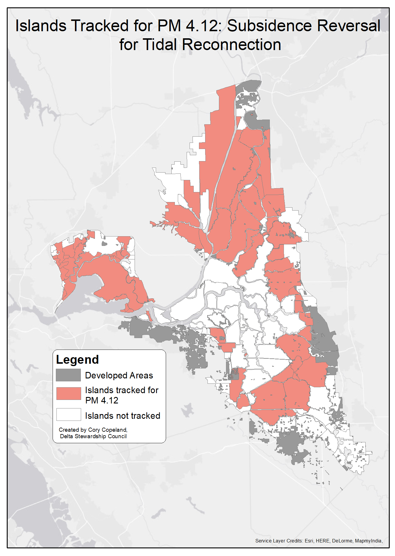
As of 2022, there are currently zero acres of Delta and Suisun Marsh land with subsidence reversal activity located on islands with large areas at shallow subtidal elevations. The map of the Delta shows the areas where wetland restoration could potentially support future process-based tidal wetland restoration.
Subsidence reversal projects are ongoing in the deeply subsided areas of the Delta and tracked by Performance Measure 5.2. Subsidence reversal activities on these deeply subsided lands are unlikely to gain enough soil accretion to reach intertidal elevations by the end of the century, nevertheless, are important to accumulate carbon and prevent further subsidence.
Next date update: Tracking will be updated annually every October.
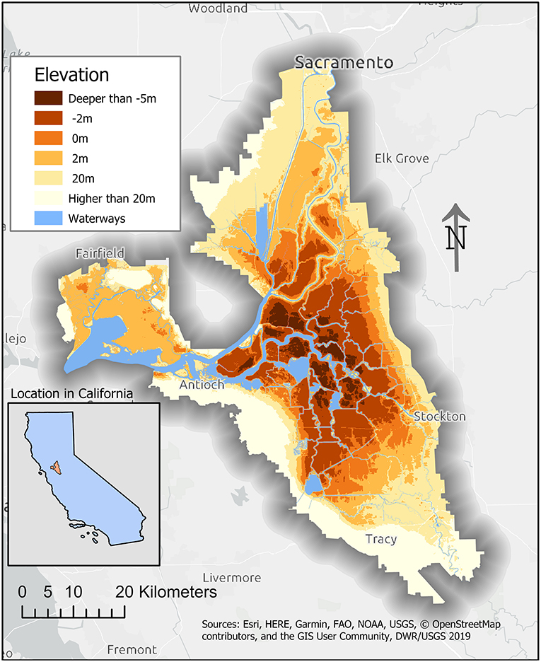
Restoration of tidal wetlands requires land at intertidal elevations. Much of the Delta that once supported these intertidal wetlands is now subsided below suitable elevations, preventing opportunities for tidal restoration. Loss of land elevation due to subsidence is ongoing and, in some portions of the Delta, more than an inch of land elevation may be lost per year. If subsidence reversal activities are located at suitable locations (see map), the accumulated land can counteract the effects of sea level rise and human-induced subsidence and maintain or increase land elevation. Recovering lost land will also preserve the opportunities for tidal reconnection. Subsidence reversal activities in locations with current shallow subtidal elevations could recover land for tidal restoration and prevent further losses from sea level rise.
Subsidence reversal is a process that increases land elevation by halting soil oxidation and accumulating new soil material. These activities are important conservation actions that can be implemented as multi-benefit projects that support native species and natural communities. Additionally, subsidence reversal projects that are managed wetlands can provide a habitat for migratory bird species and support native vegetation communities. After suitable land elevation is reached, locations can become available for tidal reconnection and tidal wetland restoration that, in turn, benefits aquatic species and native fish populations, while restoring natural geomorphic processes.
This performance measure Performance Measure 4.12, “Subsidence Reversal for Tidal Reconnection” is different from Performance Measure 5.2 because it only tracks subsidence reversal located on islands with shallow subtidal elevations, whereas Performance Measure 5.2 tracks both shallow and deeply subsided areas. Shallow subtidal elevations have a reasonable chance of achieving intertidal elevations through subsidence reversal in the timeframe from 2020 to about 2100, preventing the net loss of future opportunities to restore tidal wetlands. Deeply subsided areas may need more than 80 years to be restored to intertidal elevations making such projects unlikely to result in intertidal habitat within a planning horizon of 2100.
Subsidence in the Delta began in the 19th century when the native wetlands were drained to allow for farming. The Delta soils are highly organic formed through centuries of decaying wetland plants. When exposed to the atmosphere, these peat soils naturally oxidize. In the present-day Delta, microbial oxidation is the driver of subsidence. The result of this process is that much of the soil matter in the Delta is processed and released into the atmosphere as carbon dioxide and nitrous oxide. Both carbon dioxide and nitrous oxide are greenhouse gases that contribute to climate change. In the central Delta, subsidence is occurring quickly enough that more than one centimeter of elevation is being lost per year (Deverel et al, 2016). Because of subsidence, much of the Delta is below sea levels (Stern et al, 2022).
Delta Plan performance measure Performance Measure 5.2, “Subsidence Reversal and Carbon Sequestration,” tracks carbon sequestration projects and acres of subsidence reversal projects across the entire Delta and Suisun Marsh. It has a target of 30,000 acres of subsidence reversal and carbon sequestration in the Delta to be achieved by 2030. Managed wetlands or rice production on deeply subsided areas operated for subsidence reversal sequester carbon in the organic material they accrete. This decreases carbon emissions for organic soils. Subsidence reversal projects to sequester carbon can take advantage of carbon credit markets while also helping California meet its greenhouse gas reduction targets. Shallow subsided areas (shallow subtidal elevations) tend not to emit high amounts of carbon dioxide compared to the deeply subsided areas; therefore, it is unlikely that carbon markets will incentivize projects in these areas.
Each chapter of the Delta plan includes strategies to achieve the goals of the plan. These strategies are general guidance on achieving the objective laid out in the plan and in the Delta Reform Act of 2009. Associated with these strategies are recommendations. The recommendations describe more specific and implementable actions to support the achievement of Delta Plan strategies. Strategies and recommendations may also have associated performance measures. Delta Plan performance measures track progress in achieving desired outcomes for the Delta Plan. Below are the strategies and recommendations associated with this performance measure.
Strategy
- Protect Land for Restoration and Safeguard Against Land Loss
Recommendations
- Fund Targeted Subsidence Reversal Actions
- Funding to Enhance Working Landscapes
- Develop and Update Management Plans to Halt or Reverse Subsidence on Public Lands
Metric
Acres of Delta and Suisun Marsh land with subsidence reversal activity located on islands with large areas at shallow subtidal elevations. This metric will be reported annually.
Average elevation accretion at each project site presented in centimeters per year. This metric will be reported every five years. Tracking will continue until a project is tidally reconnected.
Baseline
In 2019, zero acres of subsidence reversal on islands with large areas at shallow subtidal elevations.
Soils in the Delta are subsiding at a rate of between zero cm/year and 1.8 cm.
Target
By 2030, 3,500 acres in the Delta and 3,000 acres in Suisun Marsh with subsidence reversal activities on islands with at least 50 percent of the area or at least 1,235 acres at shallow subtidal elevations.
For each project, an average elevation accretion of at least four centimeters per year until the project is tidally reconnected.
Methods
Information on new projects is collected from the Council’s Delta Plan covered actions portal, the San Francisco Estuary Institute (SFEI)’s Project Tracker, and other agencies implementing carbon sequestration and subsidence reversal projects, such as the Department of Water Resources’ West Delta Program and Delta Conservancy Delta Carbon Program. Implementation of projects are tracked through outreach to implementing parties.
Tracking the rate of subsidence may be done through soil core samples or potentially using remote sensing data such as digital elevation models produced using LiDAR data.
Data Sources
Performance Measure 4.12 Data Sheet Including modeling methods
Delta Plan Chapter 4: Protect, Restore, and Enhance the Delta Ecosystem
Delta Subsidence Reversal, Levee Failure, and Aquatic Habitat—A Cautionary Tale
The Dangerous Disappearance of Delta Dirt
Subsidence in the Sacramento-San Joaquin Delta
Water Availability and Subsidence in California's Central Valley
Towards the Protection, Restoration, and Enhancement of the Delta Ecosystem: A Synthesis